THE VASHON GLACIATION AND FINDING FORAGE FISH
With the Vashon Nature Centerby Adria Magrath, Winter 2022

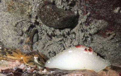
Forage fish. photo by John F. Williams
THE VASHON GLACIATION AND FINDING FORAGE FISH
With the Vashon Nature Centerby Adria Magrath, Winter 2022
Carefully shaking wet beach sand through a series of mesh screens can be a lot of fun. On a drippy gray weekend morning near the start of winter, our small group of naturalists and citizen scientists is looking for signs of forage fish. We had gathered to do this wet and cold work at the Heron Meadow at the center of Vashon Island. Snuggled next to a historic barn, this is also where the Vashon Nature Center (VNC) has set up their field station in a shipping container out of which they have been leading volunteers in the art of forage fish sample processing for years.
Forage fish is a catch-all category for all of the various species of smaller fish that are consumed by larger animals like salmon and sea birds. Because science still largely hierarchizes nature using the framework of consumerism, the great schools of herring, surf smelt, and sand lance are seen as ‘sea snacks’ rather than the center of a system supporting multitudes of species. In the VNC study, we were looking specifically for the eggs of sand lance and surf smelt deposited on the beach during spawning events.
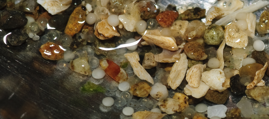

Click back and forth between the tabs above to see some of the eggs highlighted. These are surf smelt eggs collected along with some beach debris. In the hightlighted ones, the baby fish are formed enough that their dark eyes can be seen. photo by John F. Williams
This home of ours, Vashon Island, is really just a pile of heterogenous debris dropped by the most recent glacier to come and scour out the Salish Sea. Locally, this last glacial period is called the Vashon Glaciation or Stade, and it lasted for about 3000 years. It consisted of just one relatively small lobe of the Cordilleran ice sheet that covered Western Canada. This smaller lobe traveled down the Frasier River valley near modern day Vancouver B.C. and grew as far south as Tenino, which is just south of Olympia. Read Our Icy Past for more details about the movement of this “powerful ice blanket” across the region. It was an incredibly cold time, and there were musk ox, saber-toothed tigers, bison, and camels as well as mastodons and mammoths roaming around.
However, this was the furthest south the ice sheet could reach, and it had a tendency to melt from the bottom, eroding channels and creating ice cold rivers that molded the earth even faster. The ice lobe repeatedly advanced and retreated, usually melting faster than it could form, being here only because it was pushed slowly from behind by the bigger ice sheet to the north. Glaciers pick up loads of rocks and substrate, and the last one left these piles of unsorted stuff, or till, as it melted away, bringing to us an erratic array of granite boulders and the deposit that is Vashon Island, for which it is named. Read The Language of Glaciers for more details about types of glacial deposits and their other earthly molding powers.
Video clip of volunteers collecting. video by Bianca Perla
Looking for eggs under a microscope. photo by John F. Williams


Sand lance eggs stuck to sand grains under a microscope. photo by Holly Weinstein
After shaking and slopping the sandy water out of multiple bags of beach samples which had been carried to the Heron Meadow, we can still almost feel our fingers, and we are left with a smaller selection of just-the-right-sized sandy beach particles that we need. The forage fish eggs are this size, or attached to sand particles this size, so we dump them into a water vortex rigged together from gold mining equipment. The vortex separates the particles by density, and from the center of the vortex we collect the lighter matter into the finest of sieves. It is then rinsed into a clear jar, labeled well, and preserved. At a later time, someone else will scan it, manually, through a light microscope in the lab. That will tell us if forage fish have been using the sites to spawn and lay eggs. For now though, the light rain has let up and we begin to clean up the equipment, hungry from working through lunch, and the dim light already fading from the short day.
Vashon Island boasts the most undeveloped shoreline in King County, so there is interest in learning how to better care for what we have left. The samples we have just processed were collected in the darkness of night from shoreline sites around the island. Not only are we interested in knowing whether the forage fish spawn at these sites, but we are also comparing nearby sites with different qualities to see if fish use them differently. To be able to access the lower reaches of the beach, we must collect during the lowest tides which are found at night this time of year. Not a whole lot is known about forage fish biology and spawning, but we are learning more all of the time. This study is helping fill in some of the gaps. We do know that the water lapping our shores wasn’t always salty.
When the Salish Sea was covered in ice, the great age of global glaciers was already in decline, and they were shrinking worldwide. The Vashon Glaciation reached as far as it could approximately 17,000 years ago when it began to melt for good. It melted very fast by glacial standards. Sometimes the edge retreated as fast as 1,000 feet per year, and as it did so, it left behind a great body of meltwater. Some of this water drained to the ocean through southern channels, but much of it remained in the Puget Sound trough as a series of freshwater glacial lakes. As the edge of the ice receded northward, channels between the lakes were opened and they joined to form the large Glacial Lake Russel, which took up most of the South Sound and lasted the longest — for approximately 1,000 years. This freshwater lake eventually grew to include the waters in present-day Hood Canal.
As the western edge of the glacier melted even faster, it left a very large Glacial Lake Bretz covering almost all of what is now Puget Sound. Eventually the ice retreated enough to allow the water to combine with the ocean at what we now call the Strait of Juan de Fuca which had been formed earlier, also carved by ice from the same sheet. The ecological chaos that ensued must have been incredible. That was approximately 15,000 years ago, and to this day Puget Sound has been filled with seawater.
These kinds of ecological events are implicated in the evolution of anadromous fish such as salmon, that habitually spend part of their life in fresh water and part of it in salt water. Now that salmon are generally considered a culturally and commercially important species, we have dedicated quite a lot of attention and money to restoring the stocks and understanding how they best thrive — including understanding the fish they eat.
The first forage fish survey VNC ever conducted was in 2016 when they visited a shoreline site on the southeastern tip of the island. It was a long walk down a slippery cobble beach on one of those pitch-dark winter nights, complete with a sleeting, freezing rain. Picking their way with headlamps, they spotted a few items washed ashore by recent high tides including, notably, a red wooden table resting in the rocks. The three surveyors walked to three locations that first night of the study: a control site, an experimental site, and a reference site. The experimental site will undergo restoration of the beach: from bulkhead armoring to a more natural habitat. The reference site will remain a more natural habitat, while the control site will foreseeably remain a bulkheaded, or armored, area of shoreline. This work is also adding to our understanding of shoreline restoration: to detect when and if restored sites are used as habitat by forage fish and to compare it to yet undisturbed or still armored stretches of shore in the same area.
Here, a shoreline with natural habitat allows for movement of beach substrate. Substrate, in this case, is the sediments and materials covering the beach such as sand, mud, cobble, and all the broken up bits of shells. Vashon Island has been eroding into the water ever since its creation. And the organisms that use the nearshore environment have come to rely upon the natural processes that move these materials along the beach. When the shoreline gets bulkheaded or armored, it is ostensibly to stop that movement, and habitat quality is measurably altered. Bulkheads change the way the water moves along the shore, causing the waves to scour away the sand and smaller particles in different places than it otherwise would. Only the larger cobbles and less-desirable areas for forage fish spawning are left. This is just part of what happens when natural shoreline is armored, and when this kind of change occurs repeatedly along the shoreline, the loss is immeasurable.

A citizen scientist collects beach samples on Vashon Island. photo by Bianca Perla
On that night of freezing rain, with the lights of Tacoma in sight just beyond the dark waters of the Sound, the surveyors use a 100 foot tape to measure two transects, or lines, parallel to the tideline and discuss the best places to collect samples. It seems that certain species prefer to spawn at different ‘heights’ on the beach. For example, the sand lance prefers to use the lower parts of the beach where sand is present and only uncovered when the tide is at its lowest. When a likely area of sand is identified at the lower beach levels, they shovel a few shallow scoops using a hand trowel at the appropriate places, and deposit them into plastic bags with handwritten, waterproof labels. It takes a while because this is the first time doing it, and they want to be sure to get it right. They also collect photographs of the beach according to the protocol. Then everything is repeated twice at each site, so they have six bags of heavy wet sand to haul back up the beach. At a later time it will be processed through the sieves and sent to the Department of Natural Resources to be examined under a light microscope.
Eventually we will all learn that some of the samples they collected on that first night contained thousands of sand lance eggs and was the first time spawning was recorded for this beach. When they stop at the washed-up table for a brief break, they decide right then and there to bring it back to be the new desk for the Nature Center’s budding office. Laughing and moving slowly back to their starting point, helping each other, they transport the table along with the bags of sand and eventually manage to squeeze it into the back of the car, barely leaving room for one of the passengers. That was six years ago and to this day the table still serves as a desk for the Vashon Nature Center.
FIND OUT MORE
Here’s a short movie (from 2010) about collecting forage fish eggs in Kitsap County and viewing them under a microscope.
other resources
Puget Lobe Glacial Lakes by Dan Coe Carto:
https://dancoecarto.com/puget-lobe-glacial-lakes
BeachNET launches as part of larger Salish Sea restoration by Bianca Perla: https://vashonnaturecenter.org/beachnet-launches-part-larger-salish-sea-restoration/
Vashon Glaciation in Wikipedia: https://en.wikipedia.org/wiki/Vashon_Glaciation
Glacial Lakes of Puget Sound by J. Harlen Bretz: https://www.journals.uchicago.edu/doi/pdfplus/10.1086/621758

Adria Magrath is a biologist, naturalist and gardener/farmer living with her family in the heart of Puget Sound on ‘the rock’, AKA Vashon Island. When she is not teaching a biology course, running an organic farm, or spending time with family, you can find her filling in as a volunteer citizen scientist. She serves on the board of the Vashon Audubon Society, helps with their habitat restoration work in partnership with the Vashon Land Trust, and regularly volunteers for various programs such as forage fish surveys at the Vashon Nature Center.
Table of Contents, Issue #18, Winter 2022
Cold, Dark, Wet Visuals
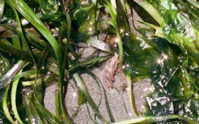
Winter 2022This opalescent nudibranch hiding amongst the swaying eel grass at Carkeek Park Beach is briefly exposed as the tide rushes out to Puget Sound. Eel grass beds hold many secrets and are often referred to as the nursery of the intertidal. Perhaps the...
Winter Characters
text and photos by Thomas Noland, Winter 2022 WINTER CHARACTERS & THEIR BEHAVIOR text and photos by Thomas NolandWhen it's cold, dark, and wet, my native plant garden provides food and shelter for many winter residents. Birds and small mammals are active, and...
Salish Sea Winter
text and photos by Michele Jaenke Winter 2022A wintery hike in Dash Point State Park. Winter snow on the Franklin Falls hiking trail. A heavy snowfall during low tide on the Puget Sound. Fall and Winter colliding in a beautiful way on a local trail. Snow brings a...
Salish Coast Cures
by Malaika Rosenfeld, Winter 2022 Nanaimo nudibranch. photo by Malaika Rosenfeldby Malaika Rosenfeld, Winter 2022the situation Swollen shades of gray horizons — wide, hanging low over dampening heads: winter in the Pacific Northwest again, and all I can think about is...

Poetry-18
Winter 2022 Looking across Hood Canal at The Brothers poking up into the sunset over the Olympics. photo by John F. WilliamsLooking across Hood Canal at The Brothers poking up into the sunset over the Olympics. photo by John F. WilliamsWinter 2022My 'Hood by Al Gunby...

Kelp Forest Decline and Reforestation
by Marina Sannes, Winter 2022 Bull kelp and eelgrass off Tongue Point in Salt Creek Recreation Area, Clallam County, WA. photo by John F. Williamsby Marina Sannes, Winter 2022An iconic and beloved image, known well to those living on the West Coast and near the Salish...
COPYRIGHT
Copyright SEA-Media
All rights reserved. Reproduction or distribution, in whole or in part. without consent of copyright owner is strictly prohibited — except for brief quotations in critical reviews and other noncommercial uses permitted by copyright laws.
SEA-Media is a 501(c)(3) nonprofit corporation
PLEASE HELP SUPPORT
SALISH MAGAZINE
DONATE
Salish Magazine contains no advertising and is free. Your donation is one big way you can help us inspire people with stories about things that they can see outdoors in our Salish Sea region.
We also don't advertise Salish Magazine, so please spread the word of this online resource to your friends and colleagues.
Thanks so much for your interest and your support.