THE LANGUAGE OF GLACIERS
by Chrys Bertolotto, Spring 2021
Photo by Tom Noland

THE LANGUAGE OF GLACIERS
by Chrys Bertolotto, Spring 2021
Photo by Tom Noland
Glaciers are such immensely powerful rivers of ice that they shape landscapes in their path. They have done this to such a degree that new words needed to be created to describe their aftermath. This essay introduces the language of glaciers through their three greatest landscape-shaping powers: erosion, transport, and deposition.
To shape a landscape, erosion must happen and glaciers do this in multiple ways. First, they can pluck (or quarry) rocks. Bedrock has gaps and cracks that are filled with air and water. When that water freezes, chunks of bedrock separate from the parent material. These loosened rocks are then available to passing glaciers to pick up and sweep into the ice matrix. Sediment of all sizes gets picked up along the way.
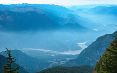
These hitchhiker rocks and passing ice then gather more stones from surrounding bedrock and rock faces through abrasion – the simple act of scraping. Abrasion acts like sandpaper, wearing away the landscape. Some sediment is so finely ground that it is called rock flour. Rock flour is what causes glacial-fed streams to be a milky color. Fluting happens when glaciers flow over jagged ridges and smooth them into teardrop shapes. Fluted ridges parallel the direction of a glacier’s movement. Subglacial streams can also cause erosion, especially where a glacier is plowing through sediment. The heavy ice sheet causes very high pressure and erosive power in these streams. They are thought to have been an important factor in carving out Salish Sea channels.The fjord landscape of the Salish Sea, characterized by steep walls and a basin filled with a mix of ocean water and freshwater runoff, is the historic footprint of the latest glacier’s erosion.
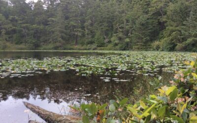
Glacial drift is the material, in a wide spectrum of types and sizes, transported by a glacier. Glaciers move in fits and starts, sometimes advancing, sometimes retreating, and sometimes at rest. Meltwater is the water released by melting snow and ice. The water can collect in lakes in front of a glacier, and very fine silt and clay particles are deposited there, creating ancient lacustrine deposits, or lake beds. Lacustrine deposits are very poor at water infiltration given the teeny tiny spaces between the teeny tiny particles – hard for water to move through.
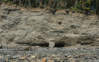
Ice chunks can be abandoned by glaciers, much like a train leaving a boxcar behind on the tracks. Over time, abandoned ice chunks are buried by sediment from the parent glacier’s meltwater. When the ice finally melts, which can take quite some time, the ground collapses, creating depressions called kettles.
And now the language of glaciers goes into overdrive. There are many different types of glacial deposits left on the landscape long after the glacier has retreated. Some of those deposits have been sifted or stratified by meltwater passing through them and others have not. Till is the general term that refers to the unsifted, heterogenous glacial drift deposited directly by glaciers. Moraines are unsifted glacial deposits that form arched hills, sometimes hundreds of feet high, along the edges or base of a glacier indicating a time of glacial rest. The US Geologic Survey includes eight types of moraines in their online dictionary of glacial terms.
There are a number of sifted or stratified glacial deposits. Preceding the glacier’s advancing edge is an outwash plain – a wide, low-gradient deposit of sediments washed from the glacier. Outwash plains may extend for miles, with sediment sizes decreasing with increasing distance from the glacier’s edge.
Rivers of meltwater can flow beneath glaciers. Stratified sand to cobble-sized gravel deposits form along the edges of meltwater streams, creating sinuous deposits called eskers. Kames are another form of stratified glacial deposit in the shape of hills, mounds, knobs, hummocks or ridges .
Because glacially-created landscape features are often a product of a combination of their erosive, transport, and deposition actions, it only seems fitting to end with two terms that are understood only by looking at all of these processes. Erratics, those rocks standing alone and unique in the landscape, are the plucked or abraded rocks that get transported some distance by glaciers and are then abandoned in a new landscape with completely different rock types. Drumlins are long hills shaped like inverted spoons. They were formed as glacial drift deposits that are then smoothed out and shaped by subsequent surges of their parent glaciers or glaciers that came afterwards.
And, I believe, this is just the tip of the iceberg (not to be confused with glaciers). If you would like to learn more, see FIND OUT MORE below.
Glossary
You can click on one of the terms below to be taken straight to its definition.

Chrys Bertolotto is a naturalist at heart. A transplant, she made her home in the Puget Lowlands by exploring the nooks and crannies of Western Washington to learn about the wildlife, plants, and people that share this dynamic landscape. Her enthusiasm often has her confusing far-off crows for fabulous raptors and creating native plant gardens on whatever patch of land she has called home. Her enthusiasm and curiosity have inspired thousands of people to fall in love with and care for this amazing place we all share.
FIND OUT MORE
Gonzalez, Mark, “What a Long, Strange (S)Trip(E) It’s Been!”, NCDS Newsletter, Vol. 30, No. 1, pg. 1
Puget Lowland Geology — a great illustrated overview of the geology of the Puget Lowlands by Washington Department of Natural Resources
Native Soils of Western Washington
A glossary of technical terms related to the ice age floods by Ice Age Floods Institute
Table of Contents, Issue #11, Spring 2021
Huge Ice Flood
by JOHN J. CLAGUE and NICHOLAS J. ROBERTS, Spring 2021The longest river in British Columbia twists through the Fraser Canyon and past the town of Hope. Photo by Michael A. Thornquist, Seaside Signs.The longest river in British Columbia twists through the Fraser Canyon...
WA Megafauna
by Thomas Noland, Spring 2021 Photos by Thomas Noland at the Burke Museum in Seattleby Thomas Noland, Spring 2021 Photos by Thomas Noland at the Burke Museum in SeattleWe’ve been lucky to find remnants of really big creatures from the past here in Washington. Not...
Whidbey Island Kettles
by Sadie Bailey, Spring 2021 Photos & video by Tom Noland except as notedby Sadie Bailey, Spring 2021 Photos & video by Tom Noland except as noted I have always loved cloudy days. The kind of days where the grey takes over the color of the world. Where the...
Poetry-11
Spring 2021 Photos by John F. WilliamsSpring 2021 Photos by John F. WilliamsShe feels the heat by Janet Knox From deep below groundDegrees add degrees the deeperHeat of exhaust bodies degassingIn cars like coffins the heat of ageDone with pregnant possibilityHer body...
Our Icy Past
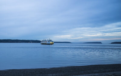
by Nancy Sefton, Spring 2021 Photos by John F. Williamsby Nancy Sefton, Spring 2021 Photos by John F. WilliamsFerries are an integral part of today’s Salish Sea region. But thousands of years ago, you could have simply walked across the Salish Sea, that is, if you...
Riches of the Prairies
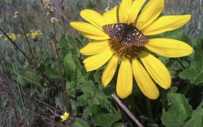
by Sarah Hamman, Spring 2021Taylor's checkerspot butterfly visiting a balsamroot flower. Photo by Sarah Hamman.by Sarah Hamman, Spring 2021The geologic history of the Puget Lowlands is filled with drama — multiple glacial advances, glacial outburst floods, tectonic...

Videos-11
Spring 2021 Photo by Cookie the Pom on UnsplashSpring 2021 Photo by Cookie the Pom on UnsplashYes, that's Videos-11, not Oceans Eleven. These are some videos that illustrate some of the ideas discussed in the articles and poems in Salish Magazine issue number 11....
COPYRIGHT
Copyright SEA-Media
All rights reserved. Reproduction or distribution, in whole or in part. without consent of copyright owner is strictly prohibited — except for brief quotations in critical reviews and other noncommercial uses permitted by copyright laws.
SEA-Media is a 501(c)(3) nonprofit corporation
PLEASE HELP SUPPORT
SALISH MAGAZINE
DONATE
Salish Magazine contains no advertising and is free. Your donation is one big way you can help us inspire people with stories about things that they can see outdoors in our Salish Sea region.
We also don't advertise Salish Magazine, so please spread the word of this online resource to your friends and colleagues.
Thanks so much for your interest and your support.